Political boundaries shown may not be accurate
Ethiopian Committee on Irrigation & Drainage
The information displayed is not the latest.
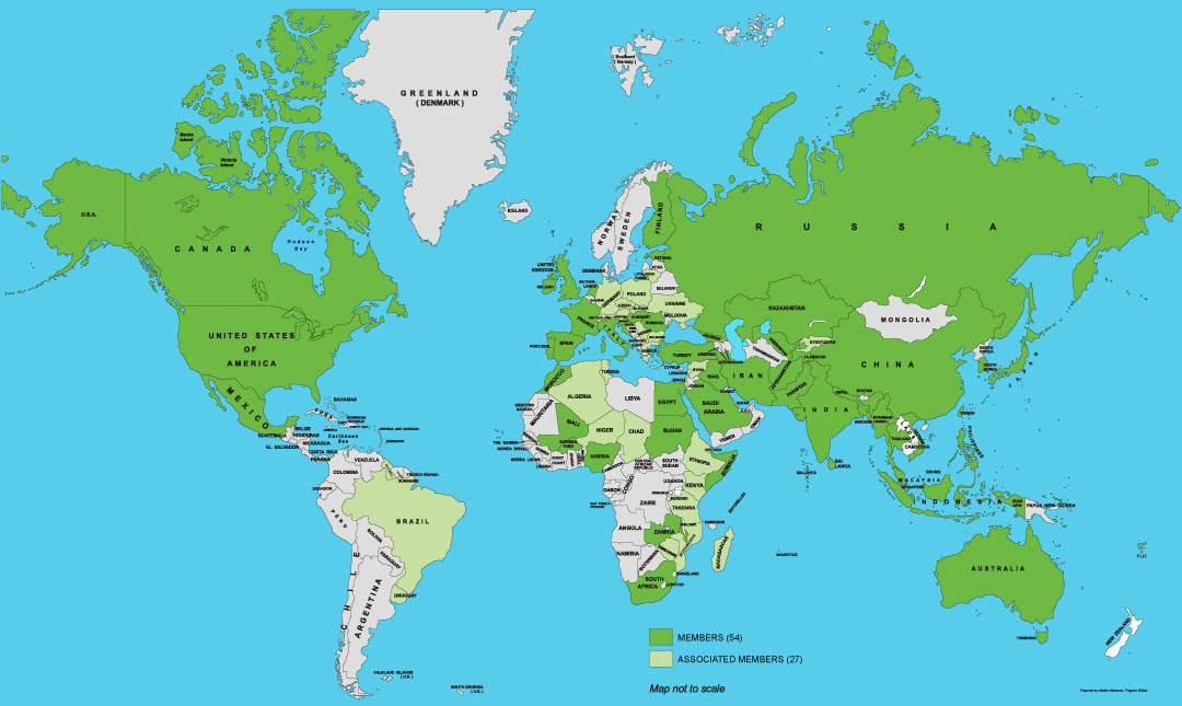
Population (M): 112
Geo. Area (Km2): 1,104,300
Irrigated Area (Mha): 0.858
Drained Area (Mha): 0.03
Sprinkler Irrigation (Ha):
Micro Irrigation (Ha): Major River Basins (Km2):
Ministry of Water and Energy, P.O. Box : 5744/5673, Addis Ababa
National Committee Directory+
Country Profile-
Geography
Ethiopia, with a total area of 1.1 MKm2, lies in the northeastern part of the Horn of Africa. The country is landlocked, sharing frontiers with Eritrea to the north and northeast, Djibouti to the east, Somalia to the east and southeast, Kenya to the south, and Sudan to the west. Ethiopia’s topographical diversity encompasses high and rugged mountains, flat-topped plateaus, and deep gorges with rivers and rolling plains with altitudes ranging from 110 m below sea level at the Denakil Depression in the northeast to over 4 600 m above sea level in the Simien Mountains in the north.
Population and land use
The country is the second-most populous country in Sub-Saharan Africa with a population of 112.1 Million as per population reference Bureau (2019). The annual population growth rate is about 2.3%. Population density is 66 inhabitants per Km2, but varies from 7 inhabitants per Km2 in Afar in the northeast to 114 inhabitants per Km2 in Southern Region in the southwest of the country. The urban population is growing rapidly as a result of both natural increase and high rural-urban migration. This is putting more and more strain on urban services and employment.
Climate and rainfall
Ethiopia’s temperatures range from equatorial desert to cool steppe. Highland plateaus, which cover more than half of Ethiopia, are surrounded by arid and semi-arid lowlands. The highlands receive large amounts of rain and serve as the watershed for the surrounding lowlands. Ethiopia has three general climatic zones: tropical in the south and southwest, cold to temperate in the highlands, and arid to semi-arid in the northeastern and southeastern lowlands. The tropical zone, below 1,800 meters, has an average annual temperature of 27°C and an average annual rainfall of less than 500 mm. The subtropical zone, which includes most of the highland plateau and lies between 1,800 and 2,400 meters above sea level, has an average temperature of 22°C and an annual rainfall ranging from 500 to 1,500 mm. Above 2,400 meters is a temperate zone with an average temperature of 16°C and an annual rainfall between 1,200 and 1,800 mm. The main rainy season occurs from mid-June to September, followed by a dry season that may be interrupted in February or March by a short rainy season. The eastern lowlands are much drier with a hot, semi-arid climate. Rainfall occurs during April, May, July, and August, and the hottest months are February and March. Nighttime temperatures may fall to near or below freezing in the mountains, particularly during the dry season. Occasionally, snow may fall on the highest peaks, but there are no permanent snowfields.
Agriculture and food
Ethiopia comprises of 110.4 Mha of land. Agricultural land area is estimated as 36.3 Mha (2015). Currently, high estimates show that only 16.3 Mha of land is under cultivation including permanent crops. Five main agricultural production systems practiced in the country comprise highland mixed farming system, lowland mixed agricultural production system, pastoral complex, Shifting cultivation, Commercial farming system. A large percent of rural households cultivated less than 2 Ha per household and 52% less than 1 Ha.
Water resources management
Ethiopia is endowed with a substantial amount of water resources. Nonetheless, the overall water resource is underdeveloped implying that there is a significant development potential both in terms of surface and ground water sources. Regarding the surface water resource, the country has a total of 12 river basins that provide an estimated annual runoff of 125 Bm3. Most of the rivers are seasonal and about 70% of the total runoff is obtained during the period June-August. Dry season flow originates from springs which provide base flows for small-scale irrigation. The groundwater potential of the country is not known with any certainty. However, initial estimates have shown that the potential varies from 2.6 to 13.5 Bm3 to the least. Groundwater has barely been exploited, given the existing capacity limitations along with hydro-geological complexity. Hence, so far only a small fraction of the groundwater has been developed mainly for local water supply purposes. Traditional wells are widely used by nomads. Neither desalinization nor treatment of wastewater is practiced in Ethiopia. Ethiopia has many small, medium and large dams constructed for hydropower generation, irrigation and drinking water supply. Small dams are less than 15m high and have a capacity of less than 3 Mm3. The height of the medium and large dams in Ethiopia is 15-50 m and their capacity ranges from 4 to 1 900 Mm3. Total dam capacity is estimated at 5.56 Km3. Out of the total of nine larger dams, only two are used for hydropower generation, one is used both for hydropower and irrigation supply, two for irrigation supply only and the remaining four for water supply to the capital city, Addis Ababa and the town of Gondar.
Irrigation and drainage
For the existing cultivated area, it is estimated that only about 4 to 5% is irrigated, with existing equipped irrigation schemes covering about 640,000 hectares. This means that a significant portion of cultivated land in Ethiopia is currently not irrigated. It is believed that well-managed irrigation development is a key to enable Ethiopia overcome the major challenges that the country is currently facing including population pressure; soil and land degradation; high climate variability, and low agricultural productivity. In addition, agricultural water development is crucial to improve smallholder livelihood and income in Ethiopia. It is also estimated that, over the next two decades Ethiopia could irrigate over 5 Mha of land with existing water sources, contributing to food security for up to six million households. A maximum irrigation potential is about 5.7 Mha, but about 3.7 Mha is commonly quoted. The irrigation potential of Ethiopia is estimated (2016) at about 2.7 Mha, considering the availability of water and land resources, technology and finance. Groundwater has not yet been considered for irrigation development, mainly due to high investment and running costs, but pilot schemes to use groundwater for irrigation have been started.
Water governance
The current federal arrangement in Ethiopia has enabled federal and regional governments to have their own constitutions. All nine regional states have their own constitutions issued after the ratification of the Federal Constitution. Almost all regional constitutions are identical in their content, except on articles that are region specific. The Federal Water Resources Management Policy (WRMP) was prepared by the Ministry of Water Resources (MoWR) and approved by the Council of Ministers in 1999. The stated policy goal is “to enhance and promote all national efforts towards the efficient, equitable and optimum utilization of the available water resources of the country for significant socio-economic development on a sustainable basis” The Ethiopian Water Resources Management Proclamation, issued in March 2000, is currently the basic legal instrument governing the Management, planning, utilization and protection of water resources in Ethiopia. The Proclamation provides the fundamental principles that need to be taken into account for the management and administration of the water resources in the country.
ICID and National Committee
The Ethiopia joined the ICID in 1976 and established the Ethiopian Committee on Irrigation & Drainage (ETCID). Mr. Teshome Atnafie Guyo is currently the Chairman of the ETCID. The ETCID can be contacted at <teshome987@yahoo.com>